DRG (topo maps)
 the
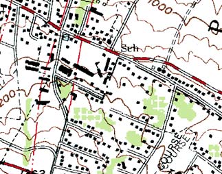
USGS produces topographical maps ("topo
maps" for short) covering (nearly) the entire USA, and distributes them in
digital form known as Digital Raster Graphics (DRG)
the
USGS produces topographical maps ("topo
maps" for short) covering (nearly) the entire USA, and distributes them in
digital form known as Digital Raster Graphics (DRG)- they usually scan the paper maps at 250 dpi, but i've also seen some
DRGs scanned at 400 dpi
- the actual files are in the common image format TIFF, in 8-bit color,
with an accompanying TFW (TIFF World File) which gives the
UTM extents of the map
- DRGs can be ordered from the USGS
for $1 per file, or a scaled-down version can be browsed online at
TopoZone
- free DRGs are available for about half of the US states, see
Locations - USA
- DRGs are used as the basis for the USGS DLG files (roads and rivers) and
DEM files (elevation produced by extracting the topo map contours and
converting them to a grid)
- however, there is a wealth of untapped data on these maps, data
which has never been fully extracted digitally, including:
- building
locations and outlines
- bridges and tunnels
- power lines
- designation of areas as schools, hospitals, cemeteries, golf courses
- in some areas, bathymetry near coastlines including mud,
reefs, and rocks
- water tanks, radio towers
- tons of other cultural features
Working with DRGs
- extracting areas of interest from DRGs, and merging data from multiple
DRGs, can be tricky process because of the 'collars' around the edges of
each map
- Global Mapper
(inexpensive, for Windows) can do this, provided you already have the
DRGs
- the BigTopo program
in the iGage - All Topo Maps product
can also do this nicely, and is sold at around $80 per U.S. State for
the DRGs and software bundled
- the VTP tool BExtractor
can automatically extract locations for buildings represented with a simple
square dot, but can not automatically extract any other kind of data
- commercial tools such as
Feature Analyst
($1k-$16k depending on license type, ArcGIS plug-in) could be used to
extract all kinds of useful information from a DRG
International Topo Maps

- many other countries and international agencies have produced their own
topo maps, which often have similarities to USGS maps in their mapping
conventions
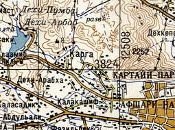
- to the right is a section of a Russian military topo map (link to
full image)
- as you can see, it also uses brown lines for elevation contours, black
rectangles for buildings, filled double lines for highways, etc.
- other countries, such as the United
Kingdom Ordnance Survey maps, have significantly different standards for
their topo map features
- see the International pages for
sources of DRGs around the world
 the
USGS produces topographical maps ("topo
maps" for short) covering (nearly) the entire USA, and distributes them in
digital form known as Digital Raster Graphics (DRG)
 the
USGS produces topographical maps ("topo
maps" for short) covering (nearly) the entire USA, and distributes them in
digital form known as Digital Raster Graphics (DRG)