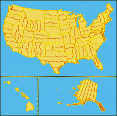
 This
"system" is actually a set of more than 100 different coordinate systems
using different projections. With the exception of Alaska Zone 1, the
projections are either Transverse Mercator or Lambert Conformal Conic (LCC).
Each state consists of one or more zones. The boundaries of these
zones always follow State lines and usually follow County lines. In States
with multiple zones, the user can generally guess at the correct zone based
on zone description and known location of the data within a state. When in
doubt, a USGS topo map of the mapping area will list the appropriate State
Plane Zone for the area, in the lower-left-hand-corner of the topo map.
The original unit of measurement for the State Plane Coordinate System (NAD27) is feet. Recently, the USGS has begun releasing 'metric' topo maps. These maps are based upon a new State Plane Coordinate System based on the NAD83 datum. This system is significantly different than the older system based on the NAD27 datum. The unit of measurement is meters, the definition of several of the zones have changed, and some zones have been dropped.
Wikipedia SPCS has more history and detail.
There is an interactive Flash map by Avenza Systems of State Plane Coordinate System Zones which displays the projection parameters of every system in every state.
See more about State Plane Coordinates and U.S. Survey Feet.