Poland
< back up to Europe
Data Sources
- main institutions are the polish cartographic survey GGK (Glówny
Geodeta Kraju, Master Surveyor of Poland) and
Glowny Urzad Geodezjii i Kartografii
(Geodesy and Cartography Main Office)
- CODGiK (Central Office for Geodetic
and Cartographic Documentation)
- conducts a digital data repository for Poland (in various scales: 1:10K
- 1:1000K)
- sells some digital data, and has information on coverage of other polish
maps and cartography visualizations
- Index for aerial photos
of Poland
- www.geoportal.gov.pl is the new
geo-portal for the country, site is all in Polish
- reported about elevation data: "DTM is diverse and depends on area
of PL. Resolution starts from 50 x 50 m; through 40x40 and 25 x 25, and
ends on 15 x 15 m. BUT in some voivodes DEM is available in resolution 10x10
m. Formats of DTM are usually DGN (Microstation) ... and sometimes in ESRI or
Mapinfo."
- LIDAR
- As of 2007, they have begin LIDAR-scanning the country, with a
project called ISOK,
"Computer System National Guards against extraordinary threats".
- The goal is from 4 to 12 points per m2.
Misc
- detailed overview
of forestry in Poland (as of 1997)
- the voivod (plural voivodes) is the political division, similar to a County
or Province, each with a governor, and some have a cartographical information
centre (WODGiK)
- University of Silesia is creating a
dataset about Upper Silesia and Cracow-Częstochowa Uplands
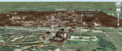
- A Historical GIS of
the city of Lublin (2012)
- Made using the Google Earth plugin, site is all in Polish.
- By floating a textured surface above the Google surface, they
can provide their own elevation and imagery, with 3D building models also
floating to match.

- contact: Tomasz Nycz ( t_nycz@strazNIESPAM.tgory.pl
)
- in Bytom, Geography Student's Science Centre - University of Silesia
(SKNG US) Faculty of Earth Sciences, Sosnowiec, Silesia voivodship
- contact: Misio ( piotrpad@priv1.onet.pl
)
- he says: "I've got some computer maps (roads, lakes/rivers, bigger
hills, cities, city maps etc.) but rather poor source of data."
- contact: Grzegorz Galezowski (
g.galezowski@mobilecomputing.pl
) in Świdnik
- he has created a VRML file of Świdnik with simple road and building
blocks - see Świdnik 3D
