Waimea Nature Park, "Ulu La‘au"
- A new 10-acre park in Waimea (Kamuela) on the Big Island
- The name, Ulu La‘au, means "garden of trees". Ulu La‘au was documented
in 1830 by the Rev. Lorenzo Lyons, founder of Waimea's 'Imiola Congregational
Church, as the Hawaiian designation for the area. More recently the land was
used for farming or pastureland.
- The park is a project of the Waimea Outdoor Circle (WOC), a branch of the
Hawai'i group The Outdoor Circle.
The WOC was formed in 1989; the park began in 1999, with real work commencing
August 2000. The WOC has an office in the 'old Lindsey building'.
- The park could really benefit from some modelling and visualization to bring
attention and help with planning
- The park doesn't have a website itself, but there is a very preliminary
Waimea Outdoor Circle site.
- Various Big Island sites mention the park in regards to volunteering to
work on the park;
googling on "Waimea Nature Park" returns a good number of hits.
Organization
- The park project is handled by WOC, and apparently the park is
also a 501(c)3 non-profit organization
- Everyone is a volunteer - it's a community effort!
Some of the People Involved
- Richard Waller, rwaller@aloha.net
(775-0601) is the master planner for the park
- Waimea Outdoor Circle (WOC) office (885-5210), email is
WOC@aloha.net
- Victor Obrastoff, writestuff04@hawaii.rr.com
(887-0500) is current WOC President
- Stephanie Donoho, stephanie@donoho-llc.com
was the WOC Volunteer Coordinator until May 2005
- Arlene Block, arleneblock@prodigy.net,
(885-4753) is former WOC President and very active with the park
- Ken Block, kenblock@prodigy.net
is described by Stephanie as 'resident guru'
- Pete Hendricks, oldsaltp@yahoo.com
(885-4453) is a guy very experienced on lots of park issues including the fish
in the stream
- Carol Hendricks, carolhe@hawaii.rr.com
used to coordinate the volunteers, and is very active with the park. She is
interfacing with some folks doing a survey of the park.
- USDA NRCS people
- Reese Libby, rlibby@hi.nrcs.usda.gov,
NRCS Waimea (885-6602x107), has GIS, GPS and other digital survey
data for the park. He also has a copy of the NRCS Emerge aerial image.
- Carolyn Wong is a NRCS soil conservationist who is assisting on the
conservation plan
- Matthew Wung is the District Conservationist for the Waimea field office
- The office is located in the "Kamuela Business Center" building - right
across the street from HPM and the Shell gas station.
- Clem Lam, architect and artist, c.lam4@verizon.net
(885-4431), chairman of Waimea Trails and Greenways, has an office right next
to the park in Carter Prof. Center
- Bob Hunter, engineer, bob@webpatent.com
(885-4144, or 885-4194) is a guy who has helped out by starting the WOC website;
his wife Mary, mary@yestech.com is also
active in WOC
- Jackie (sp?) comes in to staff the WOC office a couple afternoons a week.
- Kathryn Wiese of Retrospective Design,
retrodesign@earthlink.net, made
a lovely little 4-minute video with pictures of the park set to music
- Donna Gardner - volunteer, treasurer for the WOC and the park
- a couple nice folks within the Hart
Howarton architecture company are talking about helping out with producing
an educational building in the park - current idea is probably a long thin building
- Kadie Harris, kadie@interpac.net
(885-4872) assembles the WOC newsletter on Mac PageMaker and gets it printed
at Mike's Printing
- Deighton Emmons, teacher at HPA. As of September 2007, Pete Hendricks
has been in contact with Deighton who has done extensive GPS and GIS work on
his campus. He and Pete are in discussions to do GPS mapping of all the plants
in the Park.
Data
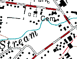
- USGS DRG doesn't show much; it was last updated in 1982. It does have
the stream in the approximately correct place, but doesn't have much else:
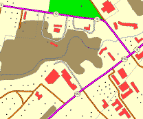
- USGS DLG (revised early 90s) is a little better. It shows approximate
extent of the vegetation (the weed trees before the park clearing began) and
more accurate data for the surrounding roads and buildings:
- Aerial photos
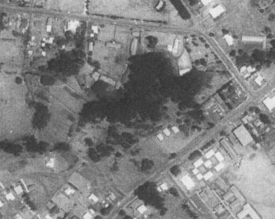
- at first i couldn't locate any recent aerials, only a grainy old 1977
aerial which shows the current park area as the only part of Waimea that
had any significant tree coverage back then:
- USDA Emerge aerial: after failing
to get a copy on DVD from the State NRCS, i got a copy of the Emerge aerial
from Reese at the local NRCS (8.4 MB MrSID file)
- Here's an JPG extract of it in the park area (click for full image):
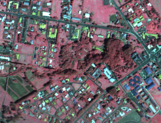
- Two structures are visible, probably the greenhouse and the tool container-shed.
- Running the Emerge image through
PixelSenseCIR
produced a fairly decent true color image, with only a few purplish areas
on the buildings and bare earth. I used PhotoShop to patch those small
areas:
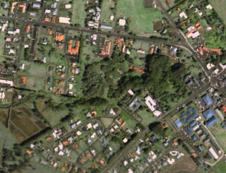
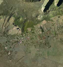
The image for all of Waimea is big (a 177MB TIF) so here it is as a
7 MB zip containing a JPEG
with a JGW (JPEG World File). If your software needs to know what
projection it is, it's NAD83 UTM zone 5. A thumbnail of the full Waimea
image:
- GPS Waypoints
- data received from Reese Libby which resulted from a GPS data-gathering
trip with local students
allwaypoint.shp (79 points) scattered over the dry side,
and a cluster in the parkbuildings.shp (2 polygons) approximate outline of greenhouse
and tool container-shedofficewaypts.shp (24 points) mostly up in North Kohala..schoolwaypoint.shp (182 points) scattered over the dry
side, and a cluster in the parkwaypoint101503.shp (39 points) all inside the park
- Some possibly usable control points for the area
- these were estimated from DLG and Emerge aerial which align within 1-2
meters (in UTM zone 5)
- main intersection of town: 220780, 2215968
- intersection of highway and CFH entry road: 220503, 2215757
- intersection of highway and Opelo Road: 219983, 2216217
- 04.12.03, i cropped and rectified a TMK map (h66003) using those three control
points.
- Using the result, i digitized the boundaries of the park:
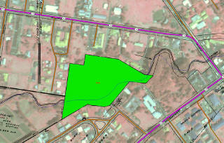
- Resulting park boundary as SHP file: park_poly_v2.zip
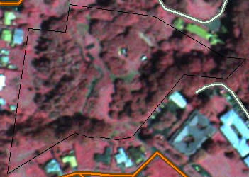
- Here is the full-resolution Emerge with the new boundary polygon overlaid:
- Elevation data
- the USGS data is not useful, as the contours are 40ft, which shows the
park area as basically flat, which it certainly isn't.
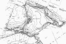
- Contours1: Some contours of the park were surveyed; received a JPG scanned
image of them. However, it was scanned at too low a resolution to
read the elevation values, so now the search is for the original contour
survey document, which is probably on blueprint paper somewhere:
 (920x621 jpg)
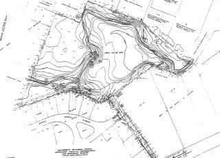
- Contours2: Received a scan from Richard on 12/14 which is 2.4x higher
resolution:
 (2656x1916 jpg)
The contours are now legible, e.g. "2640", "2650", with 2-foot contours
between them: "42", "44", "46", "48". The only area that's still hard
to read is along the stream.
- Richard reports that the original contour survey is dated 1979.
It exists on a 2x3' blueprint. He reduced it to 11x17", then again
to 8.5x11" and scanned the result at 250 or 300 dpi, which produced the
contour bitmap above.
- A better survey is underway. As of July 2005, they have reportedly
finished the elevation contours and are now working on the boundaries.
- Open questions:
- is there data for the irrigation system?
- is there any chart of where and what plants are now planted?
Boundaries and surrounding parcels
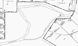
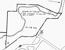
- The County website now has TMK maps online, so it's possible to download
the maps around the park. The parcels just to the north and east of the
park are in
h65003.tif; the park itself and some adjacent parcels are in
h66003.tif;
southwest of the park is a subdivision in
h66008.tif
- Interestingly, 65003 shows the stream path much more detailed than 66003
which contains the park:
-
- Unfortunately these TMK maps are not to scale, not in any known projection,
and not geolocated - which makes them pretty useless for visualization
Future Plans
The Stream
-
 Waikoloa
Stream flows through the park. This stream starts in the watershed above
the town and flows a long distance west through the desert to the ocean, on
the coast between Spencer Beach Park and the Mauna Kea Beach Hotel.
-
 The
endemic (and threatened) Hawaiian stream fish Lentipes concolor (a kind
of goby, ‘O‘opu hi‘ukole or ‘o‘opu alamo‘o) is found in the stream, although
it has not been found in the park itself. It is amphidromous (can also
live in the ocean) and is found higher up in the stream, as well as in other
streams on other Hawaiian islands. This means it must migrate through
the park section of the stream.
- There is a list of Hawai'i streams in the NPS
Rivers, Trails
& Conservation Program, but Waikoloa Stream isn't mentioned.
- Stream Survey of
Waikoloa and Keanu‘i‘omanō Streams (2002) has more detail about the stream
flow and animal life.
- The State DLNR DAR has a great site about
Hawaiian Streams
including the animals!
- More
pictures
of the goby. The female is olive to brownish all over, while the male
is brownish on the head and pale yellow to bright red on the tail.
-
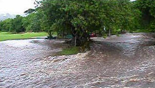 The
stream can flood big! On Sunday, March 14, 2004, Baron Sekiya wrote
in his
blog: "It was constant rain in North Hawaii today with a
downpour coming at about 10am which caused the Waikoloa Stream to overflow.
The stream flooded businesses, homes, streets and Waimea Nature Park. The park,
as seen in the above photo had the overflowing stream coursing through a grassy
area and turned it into a river, it rolled back the grassy lawn like a carpet."
The
stream can flood big! On Sunday, March 14, 2004, Baron Sekiya wrote
in his
blog: "It was constant rain in North Hawaii today with a
downpour coming at about 10am which caused the Waikoloa Stream to overflow.
The stream flooded businesses, homes, streets and Waimea Nature Park. The park,
as seen in the above photo had the overflowing stream coursing through a grassy
area and turned it into a river, it rolled back the grassy lawn like a carpet."
- This means that a fairly large part of the part is essentially a flood-plain
of the stream, which has some pretty big implications for park planning.
Traditional concrete canalization of the stream is a controversial option; it
has many drawbacks in terms of natural and visual impact, and it could just
make the flood damage worse downstream. Another option is to reduce the
degree of flooding with catchment upstream, which is surely a complex issue,
as there are already several catchment systems above town, which are clearly
not controlling flooding.
Trails
- From the County website as of 2002:
- "Waimea Trails and Greenways (County cooperating with
the Community): The first portion of the Waimea
Trail and Greenways project, directly to the left and right just inside
the entrance to the Waimea Nature Park, is now open to the public. Though
this first open stretch is less than a mile, it now connects with a network
of trails inside the Nature Park, and will eventually be ten or more miles
in length. The Trail will create a green corridor through the heart of Waimea
along the Waikoloa Stream and will provide an accessible connecting pathway
between residences, businesses & schools."
- "The proposed Waimea Trails and Greenways will begin
at a trail head at a vacant County of Hawai‘i park opposite the South Kohala
View Estates residential subdivision on the west side of Waimea Town and
proceed to Church Row in Waimea Town on the east. The approximately 4.5
miles long trail generally follows the meandering course of Waikoloa Stream
through urban and agricultural lands."
- November 23, 2004 - West Hawaii Today reports:
"The Waimea Trails and Greenways project got a boost Friday with
several key approvals. The state Board of Land and Natural Resources approved
a transfer of a lease of state land for the project. Parts of the 17.6-acre
parcel will be used for parking and access to the trail project. Board members
meeting in Honolulu also granted the county several easements to allow construction
of the trail across portions of state land."
- Waimea Trails and Greenways (WTG) has a site at
http://waimeatrails.org/
- There is also a
paragraph about WTG on
http://www.waimeaplan.org/resources/waimea/ along with a very rough
Schematic
map
- Consultant in Kona, Kaz Shigezawa does survey and drafting for the WTG trail,
including the part that goes through the park.
Press Coverage
- November 22, 2002, Honolulu Advertiser,
Big Island group aims to cultivate nature park
- a 'draft park management plan is available' - who has it? Article
says "available
for public review and comment by contacting Carolyn Stewart via e-mail at
mcsintl@flex.com"
- West Hawaii Today has covered the park occasionally, but their archives
don't seem to be online
Organizational Coverage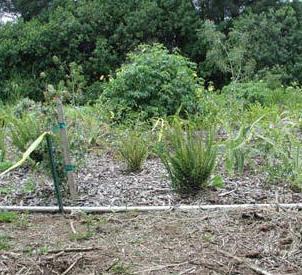
- The park is mentioned in the FWS (Fish and Wildlife Service) site in
Hawai`i Biodiversity
Joint Venture FY 2003 Funded Projects (pdf): "The Waimea
Nature Park is a 10 acre parcel of State land leased by Waimea Outdoor Circle
(WOC) for environmental research, education and restoration. WOC is developing
the moist-mesic area along the Waikoloa stream to support native aquatic and
terrestrial species. WOC will remove invasive/noxious plant species, install
a temporary fence and irrigation system to support endangered and threatened
plant species, and monitor results. WOC will also provide long-term maintenance
of these plants, keep a written and photographic record, and provide an opportunity
for environmental education for local school groups and the general public."
- The Manoa College of Tropical Agriculture and Human Resources (CTAHR) mentions
the park in their 2002 report: "Hundreds of hours of volunteer
labor, including those of 4-H members and leaders, transformed Waimea Nature
Park from a weedy jungle of alien vines to a garden of native plants for the
community to enjoy."
The Town of Waimea
- Nino Walker's Planning Thesis
Data Page has
maps and stuff for the region in which the park is situated


 (920x621 jpg)
 (2656x1916 jpg)

 Waikoloa
Stream flows through the park. This stream starts in the watershed above
the town and flows a long distance west through the desert to the ocean, on
the coast between Spencer Beach Park and the Mauna Kea Beach Hotel.
 The
endemic (and threatened) Hawaiian stream fish Lentipes concolor (a kind
of goby, ‘O‘opu hi‘ukole or ‘o‘opu alamo‘o) is found in the stream, although
it has not been found in the park itself. It is amphidromous (can also
live in the ocean) and is found higher up in the stream, as well as in other
streams on other Hawaiian islands. This means it must migrate through
the park section of the stream.
 The
stream can flood big! On Sunday, March 14, 2004, Baron Sekiya wrote
