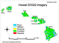
The history of the USDA/Emerge aerial photos of Hawai‘i
(USGS/USDA (NRCS/APFO) NAPP/DOQ)
- 1999: Emerge / ESpatialWeb gets a contract to gather imagery data
for all the islands
- Emerge was a subsidiary / spin-off of Litton/TASC (which was itself
later merged into Northrop Grumman)
- press release: 'Litton TASC's Emerge Subsidiary Wins Major Contract
to Produce Digital Imagery for State of Hawaii'
- commissioned by USDA's Farm Service Agency and the Natural Resources
Conservation Service (NRCS), administered
by the USDA Aerial Photography Field Office (APFO) in Salt Lake City
- for unknown reasons, the contract was to deliver false color IR, rather
than more useful multi-spectral imagery that would include a blue band
- 2000.01.20:
- they are primarily gathering IR imagery, but the sensor reportedly does
have "other bands"
- they are having the usual trouble finding any clear days to fly.
- 2000.06.06:
- data collection began in Feb. 2000, reportedly have done around 25%
of the coverage
- 2003.09.16:
- (three years later) they are mostly done - a coverage map shows the
majority of tiles are collected
- 2003.09.29:
- the HIGICC
Hawai'i I-Plan
version 1.1 (pdf) said:
- "NRCS owns this data, but makes it available to the geospatial community
in Hawai‘i in MrSID format. Issue: Slow completion of this dataset
over several years, as well as quality control issues, is causing GIS analysts
to look elsewhere for similar data. Also, digital pixel mosaic, false color
IR is not the optimum format for some applications; it is neither a good
multispectral dataset nor is it a natural looking/layman accessible backdrop
for the display of vector data or other information."
- sometime in late 2003 or early 2004,
AirPhotoUSA apparently acquired the
Emerge data and did some reprocessing to approximate truecolor imagery, then
commercially licensed the result
-
 2004.08
status:
- The NRCS "Imagery" page links back to the USGS APFO site which doesn't
have anything for Hawai‘i. Correspondence with Geoff at the APFO resulted
in a status map pdf (right), although it
isn't actually on any government website.
- 2004.09 status:
- the USGS Hawai'i Data Clearinghouse
website has giant 3 MrSID files of the Emerge imagery: (1) Kaua'i (2) Oahu
(3) Maui, Lana'i, Moloka'i, Kaho'olawe. The Big Island isn't there
yet, and the colors are RGB mapped in some unknown fashion from the original
color-infrared bands.
- 2004.11 status:
- Attempting to find the original bands, or at least a description of
what bands were captured. Contacted Henry Wolter (USGS, Honolulu).
He directed me to Pat Shade (GIS Coordinator for NRCS, Honolulu).
Pat directed me to Tony Kimmet (NRCS, Fort Worth). Pat said "In Hawaii
all we ever received from this contract was processed imagery. Tony
would either have or know if raw band files are available." I emailed
Tony on 11/4.
- Henry Wolter was kind enough to loan me a DVD copy of the Emerge tiles
that the USGS has for all the islands! Most of the data was fine,
but DVD read errors prevented me from reading a few tiles on the Big Island,
numbered 2742 to 2763.
- 2005.01 status:
- Contacted by Tony Kimmet. He says: It's nearly certain that only
3 bands were captured: IR,Red,Green. They received these bands as
raw DOQ tiles. Pat Shade has these same raw tiles. He left a
message for an APFO person to confirm that no other bands were captured.
He recommends trying out the ERDAS Imagine capability for a rough conversion
of CIR to RGB.
- Also, there are a few tiles which were captured, but weren't delivered
(e.g. they had 5% cloud cover, contract requires 0%) and some people have
actually acquired these to fill in the gaps in the tile coverage.
You'd have to contact Emerge.
- 2005.02 status:
- Contacted by Jaymes Pardue, who had been assigned to the Emerge project
from 2001 to June 2003, after the project was already going and in trouble.
Jaymes fills in several parts of the story:
- The reason that Emerge captured (R,G,IR) is that their sensor cannot
capture 4 bands at a time. A blue filter was placed in front of the
sensor, and the resulting light is split into R,G,IR. Emerge was indeed
frustrated by the original contract to deliver 0% cloud cover. The
decision was made after several years to start passing on data with up to
10% cloud cover to the USDA, just so they would have something in difficult
areas. One challenge was getting pilots stationed on each island;
e.g. when it is clear in Hilo, a pilot from Honolulu could not fly there
in time before the clouds would roll in. Emerge deserves credit for
sticking with the project, which paid $600k but surely cost them far more
to deliver.
- All the data including the partially-clouded tiles were delivered to
the USDA, and there was a very slow turnaround (up to a year) before it
got passed on to the State.
- 2005.03 status:
- Remaining Q: Where did all the partially-clouded tiles go, where are they
now?
 2004.08
status: